 |
| Markus Casey posing in front of a float plane in Lough Erne, August 2002. (P164/4/12) |
Perhaps no one made an impact on the field of aerial archaeology in Ireland quite like Galway’s own Markus Casey (1957 – 2008). Equally at home in the trenches of an excavation dig, behind the camera, or in the cockpit of a light aircraft soaring over the fields and coasts of Ireland, Casey helped uncover hundreds of lost and forgotten historical sites during his three-decade career. His substantial archive of archaeological research and photographs, which totals 14 archival boxes and includes over 20,000 photographs, now resides in the University of Galway Library Archives.
Casey was born into academia; his father, Timothy, was Professor of German at the then-University College Galway. It was here that Casey would complete his Bachelor of Arts in Archaeology and Classical Civilisation in 1983. By this point, he had already cycled across Germany and then onto Greece, joining the British School of Archaeology. His BA thesis on the study of promontory forts marked the beginning of a passion project that would last the rest of his life.
 |
Copies of Markus Casey’s 1983 BA thesis
completed at the then-University College Galway (P164/2/1/1, left) and the
first volume (covering Ulster, Leinster, and portions of County Cork) of
Casey’s series of reports on coastal promontory forts for the Heritage Council,
December 2001 (P164/2/2/2, right). |
In the world of archaeology, Casey is most known for his work on the coastal promontory forts of Ireland, dating back to his BA thesis and continuing for the rest of his life. In the last 1990s, Casey would complete his long-awaited MA dissertation at University College Dublin. Casey's thesis uncovered previously unknown and unidentified Irish coastal ring forts and other archaeological sites in the counties of Clare, Galway, Mayo and Sligo. He identified 111 definite examples of promontory forts, only 37 of which were known prior to his survey, plus another potential 57 sites. Displaying his offbeat sense of humour at the beginning of his MA thesis, Casey inserted a small piece of paper stating ‘ERRATUM: This slip has been inserted by mistake.’ Casey combined this new research with his original 1980s work and follow-up research to produce a set of reports on coastal promontory forts between 2001 and 2003 for the Heritage Council.

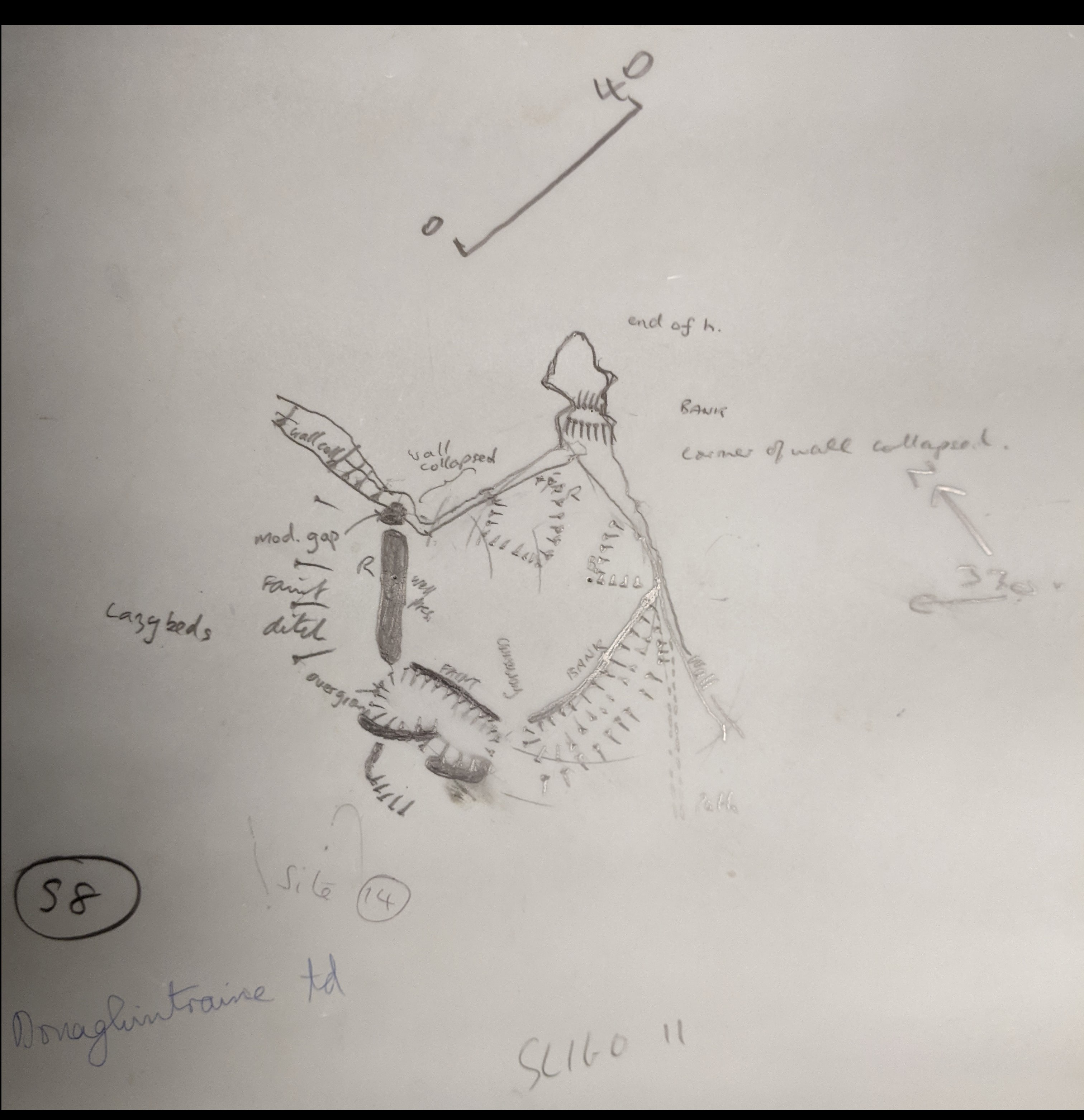 |
Site report and accompanying sketch by
Casey of the ruins of a promontory fort at Donaghintraine, County Sligo, 8 May
1985. (P164/2/4/1/1) |
 |
Aerial view of the
western tip of the Iveragh Peninsula looking toward Portmagee and Valentia
Island, Kerry, 6 April 2003. The ruins of a promontory fort are barely visible
on the headland at bottom, just left of centre. By 2006, Casey’s work was
responsible for identifying up to 77 percent of all known promontory
forts on the west coast of Ireland.
(P164/4/42/2/001) |
 |
A site report on the ruins of a promontory fort at
Illaunbeg (Illanebeg), Dursey Island, Cork, excerpted from the above report.
Descriptions of each fort include a physical location description accompanied
by one of Casey’s detailed aerial photographs. The ruins of the fort are
readily visible at centre. (P164/2/2/2) |
 |
Excavations at Doonagappul promontory fort, Clare Island, Mayo, August
1992. In the days before modern computer printing, Casey pasted his photographs
directly onto cardstock pages for his reports. (P164/2/2/6) |
Casey’s archaeological work was not merely limited to promontory forts, as he worked extensively as an archaeological consultant on various projects. At home in Galway, Casey spent much of the late 1980s and early 1990s involved with excavations pertaining to developments in the city centre, uncovering city walls and rediscovering passageways and chambers that had been lost for centuries. During the infrastructure boom of the Celtic Tiger era, Casey’s research and survey services were in high demand as roads offices and county councils across the country sought to determine if new alignments of roadways and expanded sewer systems would end up obliterating historical monuments lurking beneath the surface. Casey was also frequently called upon to inspect residential and commercial construction sites.
 |
| Excavation in Quay Lane, Galway city centre, c. 1988. As the centre of Galway underwent a heavy wave of development in the late 1980s and 1990s, Casey’s services were frequently drawn upon; it was Casey who uncovered the remains of the South Bastion of Galway’s medieval city walls in 1987. Many of the features uncovered during his surveys and excavations have been lost due to construction and are preserved only through Casey’s photographs. (P164/3/1/4) |
 |
| Casey’s eye for detail allowed him to identify from the air hundreds of archaeological features that evaded prior detection even in original Ordnance Survey maps, such as these previously-unidentified ringforts near the N5 road in the townland of Ardakillin, County Roscommon (P164/4/94/101). |
Casey balanced his archaeological passion with his other passion, aviation, in his day job as owner-operator of Shoreline Aviation, a light aircraft maintenance company based in Knock, Mayo. Markus Casey tragically perished in a 2008 crash behind the wheel of his Beechcraft Skipper 77 at Kilmovee, County Mayo, leaving behind his family and a network of colleagues and admirers who eulogised him in journals such as the Journal of the Galway Archaeological and Historical Society and Archaeology Ireland. Even today, his renown is such that the Wikipedia page on aerial archaeology has borne a direct link to an entry on Markus Casey since 2017.
Earlier this year, Casey was mentioned by his MA supervisor at Galway, emeritus Professor of Archaeology John Waddell, in Waddell’s 100 Years of University Archaeology in Galway 1924-2024, available to read here.

No comments:
Post a Comment